OUR WORK
EE Landscape Analysis for Georgia
The EE Landscape Analysis was designed to learn more about providers of environmental and outdoor learning, education for sustainability, and similar programs in the southeast; take stock of assets such as proven, exemplary models or innovative approaches; consider lessons-learned about program success and sustainability; identify gaps and obstacles that might limit equitable access; and offer analysis that could serve as a blueprint for future action.
EEA, Georgia's 30-year old 'backbone organization' for environmental education and outdoor learning, is grateful to our counterparts in the seven other southeastern states, collectively known as the Southeastern Environmental Education Alliance (SEEA), for collaborating on this project; to the Pisces Foundation and National Fish and Wildlife Foundation for funding; and to all the EE and outdoor learning providers in Georgia for the inspiring work they do every day.
Click on the button below to read the preliminary analysis of the EE landscape in Georgia.
Submit Your Organization's Profile
SEEA is still accepting profiles of non-profit organizations and public agencies in Georgia. Click the button below to enter your organization or agency profile and describe any environmental education programs, stewardship projects, or nature experiences you offer or support (educators and schools will be included later this year). As our way of saying thanks for contributing to this important analysis, respondents will receive one year of free organizational membership in EEA.
Tutorials
Tutorial for the Georgia Map |
Tutorial for the Field Trends Dashboard |

Storyboard
|
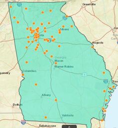
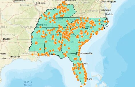
Interactive Georgia Map
The Georgia EE Landscape Analysis map can be used to find parks, forests, nature centers, schools, and other places where outdoor learning or environmental education takes place in our state. By selecting filters (indicated by icons on the left border) it is also possible to layer information about neighborhood demographics, proximity of environmental hazards or public health risks, and factors that may correlate to limited green space such as income level, Superfund sites or historically redlined neighborhoods. Note that the map takes a while to load and is complete when a black frame appears above and to the left.
In the next phase, schools will be surveyed to identify where, in what way, and how often teachers engage their students in outdoor learning or environmental education; what schoolyard improvements or amenities enhance these experiences; who schools partner with; whether the impact of their efforts have been evaluated; and what gaps or obstacles may exist.
In the next phase, schools will be surveyed to identify where, in what way, and how often teachers engage their students in outdoor learning or environmental education; what schoolyard improvements or amenities enhance these experiences; who schools partner with; whether the impact of their efforts have been evaluated; and what gaps or obstacles may exist.
Field Trends Dashboard
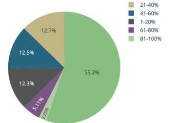
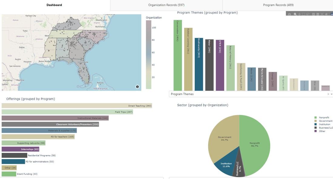
The dashboard is an interactive tool that environmental and sustainability educators, outdoor learning providers, schools, and communities can use to identify resources in their area. This is the place where you can find information about the 104 Georgia entities that completed the EE Landscape survey, as well as profiles of their signature programs. The dashboard also provides a quick snapshot of survey data via charts and graphs that can be filtered and exported.
EE and outdoor learning providers can also be filtered by state, sector (non-profit, public, private), terms that best describe the work they do, percentage of leadership that identifies as Black, indigenous, or persons of color, size of budget, program themes, audience served, offerings, academic standards, location, time, languages, and evaluation practices. Note: Use the scroll bar on the right to see additional graphs and charts. Click on the title below a chart to reveal a dropdown menu of other data that can be displayed. If you are having trouble reading the dashboard in the format below, use this link for a larger view.
EE and outdoor learning providers can also be filtered by state, sector (non-profit, public, private), terms that best describe the work they do, percentage of leadership that identifies as Black, indigenous, or persons of color, size of budget, program themes, audience served, offerings, academic standards, location, time, languages, and evaluation practices. Note: Use the scroll bar on the right to see additional graphs and charts. Click on the title below a chart to reveal a dropdown menu of other data that can be displayed. If you are having trouble reading the dashboard in the format below, use this link for a larger view.
Regional Reports and State Profiles
|
|
Environmental Education Alliance, Inc.
P.O. Box 801066 | Acworth, GA 30101 EEA does not does not discriminate on the basis of race, color, national origin, sex, age, or disability in its program , activities, or employment. For more information on EEA's non-discrimination commitment click here . Grievance officer may be contacted at [email protected] |